Amboseli is not “just” a national park. It is a living meta-ecosystem: a semi-arid savannah sustained by permanent groundwater-fed swamps and by wildlife dispersal areas that lie largely outside the park boundary. The management plan is unequivocal: the park cannot survive as an ecological island—if corridors close, swamps are degraded, and pastoral rangelands convert to fenced farms and settlements, Amboseli’s wildlife populations and tourism economy will unravel.
This guide draws primarily from the Amboseli National Park Management Plan 2020–2030 and reinforces it with credible external evidence (research, conservation partners, and ecosystem monitoring sources).
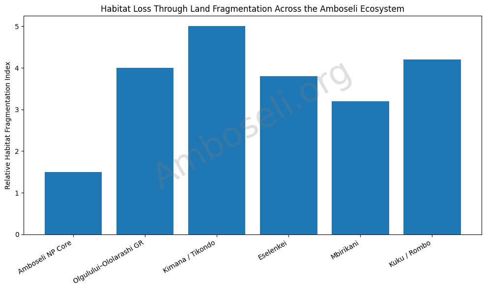
1) The #1 Threat: Land Subdivision, Sedentarization, and Habitat Fragmentation
The plan states plainly that habitat loss and degradation through group ranch subdivision and increasing sedentarization is the greatest threat to viable wildlife populations in the Amboseli ecosystem—because it breaks up dispersal areas, blocks corridors, and accelerates land conversion away from wildlife-compatible pastoralism.
What’s happening on the ground (management-plan evidence)
Every surrounding group ranch is in some stage of subdivision or conversion, with some already subdivided, others partially subdivided, and others preparing surveys that will lead to subdivision. The plan’s Table 4 documents the scale and trajectory across the core ranches that form Amboseli’s “life support system” outside the park:
- Kimana/Tikondo: 25,120 ha — subdivided
- Olgulului/Ololarashi: 147,050 ha — subdivision approved; already carried out in arable areas (including around Namelok swamp / Entonet-Kitenden)
- Kuku “B”: 96,000 ha — subdivision in arable areas
- Rombo: 38,000 ha — ~half subdivided and extending into rangeland
- Eselenkei: 74,794 ha — survey to commence; large-scale subdivision planned except conservancy area
- Mbirikani: 122,893 ha — subdivision around swamps
Why this is existential
Amboseli’s wildlife must move to survive: to access seasonal grazing, water, mineral licks, calving grounds, and drought refuges. The plan highlights multiple corridor choke points already under pressure—especially the Kilimanjaro–Amboseli gradient and the Kimana / Namelok / Lenker wetlands.
2) Corridor Collapse: When the “Arteries” of Amboseli Close
The management plan provides a rare, specific threat map in words—naming the exact corridors and what is blocking them.
Key corridor threats inside the Amboseli ecosystem (Table 5)
| Corridor / area | Main pressure | What it causes |
|---|---|---|
| Dispersal areas south of the park | farming, settlement, subdivision | loss of corridors to/from Kilimanjaro forest |
| Loitokitok pipeline zone | settlement | curtailed migrations between Amboseli and Mbirikani; reduced access to Chyulu Hills |
| Namelok & Kimana | subdivision, crop farms, fences | curtailed movements, especially elephants |
| Kimana & Lenker swamps | farming and irrigation | elimination of swamps critical to livestock & wildlife; threatens sanctuaries and tourism facilities |
| Kimana individual plots | unplanned tourism development | curtailed movements, especially elephants |
Connectivity threats to adjoining ecosystems (Table 6)
The plan flags a wider connectivity crisis: links to Chyulu Hills, Tsavo West, Selengei/Eastern Kaputei, and Kilimanjaro are being severed by settlement, farming, fencing, forest loss, water diversions, and subdivision.
External studies echo this. For example, analysis of the Kitenden Wildlife Corridor documents how land use and tenure changes constrict habitat and threaten corridor viability.
Why this matters: If corridors fail, drought becomes deadlier, conflict intensifies at the edges, genetic exchange declines, and the park increasingly resembles a fenced zoo—without the funding security of a fenced zoo.
3) Water Is the Hidden Battlefield: Swamps, Springs, Abstraction, and Pollution
Amboseli is a semi-arid system made globally famous by permanent swamps (notably Enkongo Narok and Longinye) that act as the ecosystem’s dry-season lifeline.
Yet the plan’s threat ranking is stark: water abstraction is “Very High” as a threat to swamps/springs (and also “High” to woodlands).
How water threats cascade
- Irrigated agriculture at swamp edges converts critical drought refuges into private production zones and reduces shared water access. The plan specifically warns that Kimana and Lenker swamps—vital to wildlife and livestock—are being eliminated by farming and irrigation.
- Water pressures do not stop at the park line. External wetland research in the Amboseli dispersal area describes wetland conversion and water abstraction as direct threats to the persistence of key swamps near the park.
If the swamps degrade, Amboseli’s signature wildlife aggregations shrink, dry-season mortality rises, and conflict at farms and bomas spikes because animals concentrate where water remains.
4) Overgrazing and Loss of Grassland: A Slow-Moving Collapse
The plan calls heavy grazing pressure a major threat, linking it explicitly to declining pasture production and to wildlife and livestock losses. Importantly, it cites long-term counts showing heavy sustained grazing as the primary cause of livestock and wildlife losses in the ecosystem.
The plan also connects grassland loss to:
- dryland farming and irrigated wetland farming
- sedentarization (reduced mobility)
- breakdown of traditional grazing rotation systems
This is not a “pastoralism vs wildlife” story. It is a rangeland governance story: mobility, planned grazing, and intact dispersal lands are what historically allowed people, livestock, and wildlife to co-exist at scale.
5) Human–Wildlife Conflict: Now Undercutting Conservation Gains
The management plan warns that human–wildlife conflict has “risen sharply” and is now undermining community-based conservation—manifesting as livestock predation, crop raiding, and human injury/death.
The plan’s hotspot map (2015–2019) and hotspot list
The plan identifies specific HWC hotspot areas and the main problem animals (notably elephants and lions). Examples include: Lenkism (elephants & lion), Osewani (elephants & lions), Kitirua (lions), Marba (lions, buffalo & elephants), plus bushmeat-related hotspots such as Kisajani, Entonet, Simba Cement.
Why conflict is escalating
Conflict rises when:
- corridors are blocked (animals are forced through farms and settlements),
- drought compresses wildlife around water and green forage,
- fenced plots prevent “giving space” during seasonal movements.
A recent external example from Big Life (one of the ecosystem’s major partners) illustrates how shrinking space is associated with increasing crop-raiding incidents in the Amboseli landscape.
What is working (and why it needs scale)
The plan emphasizes institutional responses like the Amboseli Human–Wildlife Co-existence Committee (HWCC) and practical mitigation: fences, rapid response, and predator-proof bomas. It notes that Born Free has already constructed 326 predator-proof bomas in livestock predation hotspots
6) Poaching: Reduced, Not Gone — and Tied to Livelihood Stability
The plan reports that poaching has declined to manageable levels since the previous plan period, partly linked to a large, well-managed community ranger force—but trophy and bushmeat poaching still occurs. Critically, it stresses that anti-poaching success depends on community welfare and incentives
This aligns with the plan’s broader logic: when communities lose access to land benefits, suffer uncompensated losses, or face livelihood shocks, illegal use pressures rise—especially bushmeat.
7) Drought and Climate Risk: The 2009 Die-Off Was a Warning Shot
The plan gives one of the most sobering statistics in the document:
- Drought in ASAL systems like Amboseli historically recurs every 10–15 years.
- In the 2009 drought, the plan reports:
- Over 95% of wildebeest died
- 60% of zebra and cattle died
- A quarter of elephants died
- all within roughly six months
It further explains that the 2009 drought was far more severe than the 1970s because space and pasture were restricted, and it notes wildebeest numbers dropped to about 200, with recovery dependent on immigration from outside areas.
External ecosystem monitoring sources also use 2009 as a benchmark drought catastrophe and discuss subsequent drought impacts and recovery patterns.
Amboseli’s lesson: drought is not “new”—but fragmentation turns drought into a mass mortality event.
8) Agricultural Expansion and Wetland Conversion: A Direct Corridor and Refuge Threat
The plan identifies zones most suited for non-intensive rain-fed agriculture (LM5 and UM4) and notes increasing adoption of rain-fed and irrigated cropping as a drought coping strategy—often at precisely the places wildlife depend on in the dry season: swamp edges and rivers.
This is the trap: drought pushes households toward irrigation and cultivation; cultivation reduces drought refuges and corridors; reduced refuges intensify drought losses and conflict; conflict erodes conservation tolerance.
9) Tourism and Infrastructure Pressure: Not the Biggest Threat, But a Multiplier
Amboseli is among Kenya’s most visited protected areas, hosting 150,000+ visitors annually.
High visitation increases the burden on roads, viewing loops, waste systems, and sensitive habitats—especially around swamps. When combined with land-use change and water constraints, poorly planned tourism development (including “unplanned tourism development” on individual plots in key dispersal areas) becomes another corridor pressure.
10) The Underlying Driver: Socioeconomic and Demographic Change
The plan explicitly lists social, economic and demographic changes among the top ecosystem-wide issues it must address.
In practical terms, this includes:
- rising settlement density,
- changing livelihoods and aspirations,
- shifting land tenure patterns,
- competing water demands,
- and increased infrastructure footprints (pipelines, roads, trading centers).
This driver is why “business as usual” conservation messaging fails. The plan’s approach is not nostalgia—it is a new deal: conservation must fund community benefit, land security, coexistence tools, and governance capacity at ecosystem scale.
The Case for Conservation: What Amboseli.org Must Say Clearly
The management plan’s warning is unambiguous: without immediate action to safeguard dispersal areas and implement agreed land-use zoning, Amboseli could become an ecological island.
From an Amboseli.org standpoint, the conservation case rests on five truths:
- Amboseli’s wildlife lives on community land as much as it lives in the park.
Corridors and dispersal areas are not optional; they are the system. - Water is the keystone resource.
Swamps and springs must be protected from over-abstraction, pollution, and wetland conversion. - Fragmentation turns normal drought cycles into ecological catastrophes.
2009 proved this with extreme mortality figures. - Human–wildlife coexistence is now the frontline.
Hotspots are known; mitigation works when maintained and scaled (fences, HWCC, predator-proof bomas, compensation systems). - Community benefit is not a “nice to have”—it is the price of persistence.
The plan links poaching risk and conservation success directly to livelihood stability and incentive structures.
What a “Serious” Conservation Response Looks Like (Aligned to the Plan)
If Amboseli.org is to be the official voice that moves the needle, the response must emphasize concrete, ecosystem-scale interventions:
- Secure corridors and dispersal areas through community conservancies, enforceable land-use plans, and land/lease mechanisms that keep priority rangelands open.
- Defend the swamps: regulate abstraction, protect spring catchments, and stop wetland conversion in the Kimana/Lenker system.
- Scale coexistence infrastructure: maintain functional fences (e.g., Kitenden–Kimana), expand predator-proof bomas, strengthen PAC outposts and rapid response.
- Treat rangeland health as wildlife health: planned grazing, restored mobility, and protection of dry-season pastures.
- Protect with people: grow community ranger capacity and ensure conservation delivers tangible household-level benefit to reduce retaliatory killing, bushmeat demand, and tolerance collapse.